
Since the creation of Geosiris in 2012:
- 23 communications were presented in conferences (including 10 to EAGE and 3 to SPE).
- 3 papers were presented in rank A scientific journals
- 2 government supported co-research contracts were operated.
- M. Perrin and J.F. Rainaud were the major contributors and editors of a book dedicated to Shared Earth Modeling.
Major publications
Books
Perrin, Michel; Rainaud, Jean-François
Shared Earth Modeling: Knowledge Driven Solutions for Building and Managing Subsurface 3D Geological Models Book
Technip, 2013, ISBN: 9782710810025.
@book{perrin:rainaud:2013,

title = {Shared Earth Modeling: Knowledge Driven Solutions for Building and Managing Subsurface 3D Geological Models},

author = {Michel Perrin and Jean-François Rainaud},

isbn = {9782710810025},

year  = {2013},

date = {2013-02-01},

urldate = {2013-02-01},

pages = {424},

publisher = {Technip},

abstract = {-	Part 1: Earth models (3 chapters)

-	Part 2:  Knowledge oriented Solutions (5 chapters)

-	Part 3: Knowledge Formalization (4 chapters)

-	Part 4:  knowledge Management and applications

},

keywords = {},

pubstate = {published},

tppubtype = {book}

}
- Part 2: Knowledge oriented Solutions (5 chapters)
- Part 3: Knowledge Formalization (4 chapters)
- Part 4: knowledge Management and applications
Inproceedings
Untereiner, Lionel; Rainaud, Jean-François; Perrin, Michel; Gauthier, Valentin
A Cloud-Native Standard-based Geoscientific Workflow Architecture for improving geomodelers’ collaboration Inproceedings Forthcoming
In: 83rd EAGE annual conference and exhibition, Madrid, Forthcoming.
@inproceedings{eage,

title = {A Cloud-Native Standard-based Geoscientific Workflow Architecture for improving geomodelers’ collaboration},

author = {Lionel Untereiner and Jean-François Rainaud and Michel Perrin and Valentin Gauthier},

year  = {2022},

date = {2022-06-01},

urldate = {2022-06-01},

booktitle = {83rd EAGE annual conference and exhibition},

address = {Madrid},

keywords = {},

pubstate = {forthcoming},

tppubtype = {inproceedings}

}
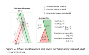
Rainaud, Jean-François; Bac, Alexandra; Perrin, Michel; Daniel, Marc; Untereiner, Lionel
Fault Modeling and Analysis using Implicit Functions Inproceedings
In: 82nd EAGE Annual Conference & Exhibition, pp. 1-5, European Association of Geoscientists & Engineers European Association of Geoscientists & Engineers, 2021, ISBN: 2214-4609.
@inproceedings{RBPDU21,

title = {Fault Modeling and Analysis using Implicit Functions},

author = {Jean-François Rainaud and Alexandra Bac and Michel Perrin and Marc Daniel and Lionel Untereiner},

doi = {10.3997/2214-4609.202112530},

isbn = {2214-4609},

year  = {2021},

date = {2021-10-01},

urldate = {2021-10-01},

booktitle = {82nd EAGE Annual Conference & Exhibition},

volume = {2021},

number = {1},

pages = {1-5},

publisher = {European Association of Geoscientists & Engineers},

organization = {European Association of Geoscientists & Engineers},

series = {EAGE Annual Conference & Exhibition},

keywords = {},

pubstate = {published},

tppubtype = {inproceedings}

}
Gauthier, Valentin; Labourg, Pierre; Leonard, Jean-Marie; Rainaud, Jean-François
Operational Use Cases Using RESQML Standard to communicate Geotechnics and Subsurface Information to BIM. Inproceedings
In: near Surface Geosciences EAGE Conference and Exhibition, pp. 1-5, European Association of Geoscientists & Engineers, Bordeaux, 2021, ISSN: 2214-4609.
@inproceedings{eage:/content/papers/10.3997/2214-4609.202120060,

title = {Operational Use Cases Using RESQML Standard to communicate Geotechnics and Subsurface Information to BIM.},

author = {Valentin Gauthier and Pierre Labourg and Jean-Marie Leonard and Jean-François Rainaud},

doi = {https://doi.org/10.3997/2214-4609.202120060},

issn = {2214-4609},

year  = {2021},

date = {2021-01-01},

booktitle = {near Surface Geosciences EAGE Conference and Exhibition},

volume = {2021},

number = {1},

pages = {1-5},

publisher = {European Association of Geoscientists & Engineers},

address = {Bordeaux},

keywords = {},

pubstate = {published},

tppubtype = {inproceedings}

}
Journal Articles
Garcia, Luan Fonseca; Abel, Mara; Perrin, Michel; dos Santos Alvarenga, Renata
The GeoCore ontology: A core ontology for general use in Geology Journal Article
In: Computers & Geosciences, vol. 135, pp. 104387, 2020, ISSN: 0098-3004.
@article{Garcia2020TheGO,

title = {The GeoCore ontology: A core ontology for general use in Geology},

author = {Luan Fonseca Garcia and Mara Abel and Michel Perrin and Renata dos Santos Alvarenga},

doi = {10.1016/j.cageo.2019.104387},

issn = {0098-3004},

year  = {2020},

date = {2020-02-01},

journal = {Computers & Geosciences},

volume = {135},

pages = {104387},

abstract = {Domain ontologies assume the role of representing, in a formal way, a consensual knowledge of a community over a domain. This task is especially difficult in a wide domain like Geology, which is composed of diversified science resting on a large variety of conceptual models that were developed over time. The meaning of the concepts used by the various professionals often depends on the particular vision that they have of a domain according to their background and working habits. Ontology development in Geology thus necessitates a drastic elucidation of the concepts and vocabulary used by geologists. This article intends to contribute to solving these difficulties by proposing a core ontology named GeoCore Ontology resting on the BFO top ontology, specially designed for describing scientific fields. GeoCore Ontology contains well-founded definitions of a limited set of general concepts within the Geology field that are currently considered by all geologists whatever their skill. It allows modelers to separately consider a geological object, the substance that constitutes it, the boundaries that limit it and the internal arrangement of the matter inside it. The core ontology also allows the description of the existentially dependent qualities attached to a geological object and the geological process that generated it in a particular geological age. This small set of formally defined and described concepts combined with concepts from BFO provides a backbone for deriving by subsumption more specialized geological concepts and also constitutes a baseline for integrating different existent domain ontologies within the Geology domain. The GeoCore ontology and the methodology that we used for building it, provide solutions for unveiling major misunderstanding regarding the concepts that are commonly used for formulating geological interpretations. This will facilitate the communication of this information to external Geology users and its integration in domain applications.},

keywords = {},

pubstate = {published},

tppubtype = {article}

}
Rainaud, Jean-François; Clochard, Vincent; Delépine, Nicolas; Crabié, Thomas; Poudret, Mathieu; Perrin, Michel; Klein, Emmanuel
Building a 3D faulted a priori model for stratigraphic inversion: Illustration of a new methodology applied on a North Sea field case study Journal Article
In: Journal of Applied Geophysics, vol. 154, pp. 128-135, 2018, ISSN: 0926-9851.
@article{RAINAUD2018128,

title = {Building a 3D faulted a priori model for stratigraphic inversion: Illustration of a new methodology applied on a North Sea field case study},

author = {Jean-François Rainaud and Vincent Clochard and Nicolas Delépine and Thomas Crabié and Mathieu Poudret and Michel Perrin and Emmanuel Klein},

doi = {https://doi.org/10.1016/j.jappgeo.2018.04.011},

issn = {0926-9851},

year  = {2018},

date = {2018-01-01},

journal = {Journal of Applied Geophysics},

volume = {154},

pages = {128-135},

abstract = {Accurate reservoir characterization is needed all along the development of an oil and gas field study. It helps building 3D numerical reservoir simulation models for estimating the original oil and gas volumes in place and for simulating fluid flow behaviors. At a later stage of the field development, reservoir characterization can also help deciding which recovery techniques need to be used for fluids extraction. In complex media, such as faulted reservoirs, flow behavior predictions within volumes close to faults can be a very challenging issue. During the development plan, it is necessary to determine which types of communication exist between faults or which potential barriers exist for fluid flows. The solving of these issues rests on accurate fault characterization. In most cases, faults are not preserved along reservoir characterization workflows. The memory of the interpreted faults from seismic is not kept during seismic inversion and further interpretation of the result. The goal of our study is at first to integrate a 3D fault network as a priori information into a model-based stratigraphic inversion procedure. Secondly, we apply our methodology on a well-known oil and gas case study over a typical North Sea field (UK Northern North Sea) in order to demonstrate its added value for determining reservoir properties. More precisely, the a priori model is composed of several geological units populated by physical attributes, they are extrapolated from well log data following the deposition mode, but usually a priori model building methods respect neither the 3D fault geometry nor the stratification dips on the fault sides. We address this difficulty by applying an efficient flattening method for each stratigraphic unit in our workflow. Even before seismic inversion, the obtained stratigraphic model has been directly used to model synthetic seismic on our case study. Comparisons between synthetic seismic obtained from our 3D fault network model give much lower residuals than with a “basic” stratigraphic model. Finally, we apply our model-based inversion considering both faulted and non-faulted a priori models. By comparing the rock impedances results obtain in the two cases, we can see a better delineation of the Brent-reservoir compartments by using the 3D faulted a priori model built with our method.},

keywords = {},

pubstate = {published},

tppubtype = {article}

}
Abel, Mara; Perrin, Michel; Carbonera, Joel Luis
Ontological analysis for information integration in geomodeling Journal Article
In: Earth Science Informatics, vol. 8, no. 1, pp. 21-36, 2015, ISSN: 1865-0481.
@article{Abel2015,

title = {Ontological analysis for information integration in geomodeling},

author = {Mara Abel and Michel Perrin and Joel Luis Carbonera},

doi = {10.1007/s12145-015-0211-9},

issn = {1865-0481},

year  = {2015},

date = {2015-03-01},

journal = {Earth Science Informatics},

volume = {8},

number = {1},

pages = {21-36},

abstract = {When building earth models, data heterogeneity is a major difficulty. Heterogeneity can be a consequence of different geologists' views or goals when capturing the data, or can be a result of representing the geological models through distinct modeling languages. We analyze here how each one of these causes affect the way in which the geological information is captured into models and systems. The major claim of this paper is that many problems related to these heterogeneities can be solved or at least simplified by analyzing the models through the view of Ontology. We assume that heterogeneity is originally related to the different choices that a geologist makes, when she/he decides to consider a particular set of qualities among the large number of qualities that are attached to the entities that she/he intends to model. Considering this, for deciding which attributes hold the ontological nature of a given category of geological entity, one can apply the ontological notions of identity, rigidity, essentiality and unity. This allows solving the difficulties due to the heterogeneity of modeling languages by identifying, among the many entities and properties considered by the geologists, those that are eligible for being mapped from one model to another, not considering the name that they bear or the format in which they are represented. This paper also discusses how to build good models for further integration, avoiding some common misuse of hierarchical and partonomy relationships, and the limitations of the current available representation languages. Finally, we examine as a case study the ``Petroleum system'', providing a concrete example for explaining how some issues related to data heterogeneity can be dealt with in practice.},

keywords = {},

pubstate = {published},

tppubtype = {article}

}
Bennis, Chakib; Borouchaki, Houman; Dumont, Cyrielle; Lerat, Olivier; Poudret, Mathieu; Rainaud, Jean-François
3D line-support grid flattening for more accurate geostatistical reservoir population with petrophysical properties. Journal Article
In: Engineering with Computers, vol. 30, no. 3, pp. 403-421, 2014.
@article{bennis:hal-01052688,

title = {3D line-support grid flattening for more accurate geostatistical reservoir population with petrophysical properties.},

author = {Chakib Bennis and Houman Borouchaki and Cyrielle Dumont and Olivier Lerat and Mathieu Poudret and Jean-François Rainaud},

doi = {10.1007/s00366-012-0311-9},

year  = {2014},

date = {2014-07-01},

journal = {Engineering with Computers},

volume = {30},

number = {3},

pages = {403-421},

publisher = {Springer Verlag},

keywords = {},

pubstate = {published},

tppubtype = {article}

}